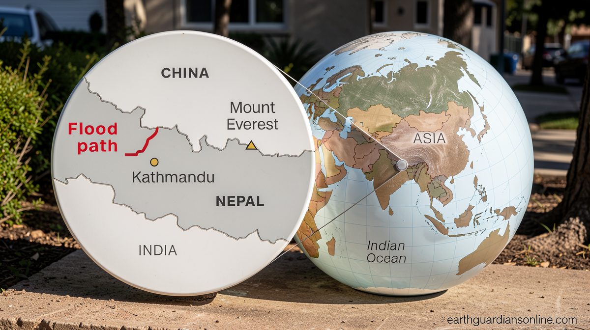
Landslides and floods have wreaked havoc in Nepal and China. Follow the river down the path of destruction.

Daftar Isi
Mountains Give Way: Catastrophic Landslides and Flash Floods Devastate the Nepal-China Border Region
Earthguardiansonline.com – The Himalayan footholds along the Nepal-China frontier have been struck by a sequence of geological and hydrological disasters of extraordinary severity. Beginning with a major landslide on August 26, the terrain has been progressively torn apart by cascading slope failures and sudden, violent flash floods that have swept through valleys on both sides of the international boundary. At least 675 people have been confirmed dead in the aftermath, while roughly 3,000 residents remain missing across the affected districts in Nepal and the adjoining Chinese territories. The scale of the destruction — collapsed homes, severed bridges, and entire settlements buried under debris — marks one of the deadliest natural-disaster episodes in the region’s recent history.
A Chain Reaction in the High Country
The initial landslide of August 26 did not act in isolation. In the days that followed, saturated slopes continued to fail, sending torrents of rock, soil, and glacial meltwater plunging into narrow river channels. Where the terrain funneled the flow into confined valleys, water levels rose within minutes, producing flash floods of a ferocity that left little time for evacuation. Structures built along these corridors — timber houses, concrete bridges, and earthen embankments — were carried away or crushed under the weight of debris. The result was a landscape of rubble where communities had lived for generations.
The Nepal-China border zone sits at the junction of the eastern Himalayan fold-and-thrust belt, where tectonic uplift meets intense monsoon rainfall. Roads and bridges in this area are often single-lane, lightly engineered structures that struggle to withstand even moderate flooding. When a landslide of the magnitude observed on August 26 blocks a river, the upstream water accumulates rapidly, and the downstream reach is left exposed until the dammed volume eventually overtops or breaches its natural barrier. Engineers and disaster-management officials describe this as a “secondary hazard” scenario: the first event creates the conditions for a second, potentially larger, catastrophe.
Three Thousand Unaccounted For
Rescue operations face formidable obstacles. Many of the hardest-hit settlements sit in remote valleys accessible only by footpaths or single-span bridges, several of which have been destroyed. Helicopter access is limited by persistent cloud cover and gusty winds typical of late-monsoon conditions. On both the Nepali and Chinese sides of the border, local authorities have mobilized army units, civil-defense teams, and volunteer search parties, yet the sheer volume of debris and the ongoing risk of further slope failure slow every advance. Families in neighboring districts have gathered at temporary shelters, waiting for word of relatives whose last known location places them within the flood-affected corridor.
The cross-border dimension of the disaster adds logistical complexity. Coordination between Nepali and Chinese rescue agencies must account for differing command structures, language barriers, and the physical reality that rivers do not respect political boundaries. Officials on both sides have indicated that joint search-and-rescue efforts are underway, though the pace remains constrained by terrain and weather.
Two New Lakes and the Threat of a Second Flood
Perhaps the most urgent concern facing disaster managers now is the formation of two temporary lakes upstream of the primary landslide scar. These landslide-dammed lakes — bodies of water held back by walls of collapsed earth and rock — can grow by tens of meters per day while inflow continues. If either lake overtops its natural dam, or if the dam structure fails under the pressure of accumulated water, a sudden release could send a wall of floodwater downstream with little warning to communities situated in the valley below.
Officials have placed continuous monitoring stations at both lakes, tracking water-level rise, dam-crest stability, and inflow rates. Evacuation plans for downstream villages have been activated as a precaution. The window in which authorities can act before a potential breach is narrow, and every hour of stable weather is treated as time to complete protective measures.
Weekend Rain Deepens the Danger
Meteorological forecasts indicate that additional rainfall is expected over the flood-affected districts later this weekend. Even moderate rain on already-saturated slopes can trigger fresh landslides, increase river discharge, and accelerate the filling of the two dammed lakes. Disaster-management agencies have raised alert levels in the most vulnerable wards and are pre-positioning rescue assets at staging points above likely flood paths. Residents in low-lying areas have been advised to move to higher ground before the next weather system arrives.
What the Imagery Reveals
Satellite passes over the affected valleys, combined with ground-level video captured by residents and journalists before communications were severed, paint a picture of destruction of immense scale. River channels that once ran clear and narrow now carry brown, sediment-laden torrents. Forested hillsides show fresh scars where entire slopes have detached. Villages that appeared intact in pre-event imagery are reduced to scattered fragments of roofing material and exposed foundations. The contrast between before and after, visible in side-by-side satellite frames, underscores how quickly a single geological event — amplified by monsoon rainfall — can erase decades of settlement and infrastructure.
For the communities of the Nepal-China border, the coming days will determine whether the worst of the secondary flood risk can be managed before the weekend rains arrive. The mountain, for now, has spoken. The question is whether the people below it can outrun what it says next.
Related Reading
Frequently Asked Questions
What is Landslides and floods have wreaked havoc?
Landslides and floods have wreaked havoc is the main topic of this guide. The article explains the context, practical details, and next steps readers should understand.
Why does Landslides and floods have wreaked havoc matter?
Landslides and floods have wreaked havoc matters because readers are looking for a useful answer, not just a short summary. Good content should match search intent and help them decide what to do next.