Major flood threat for Texas and Gulf states this week as potential tropical system supercharges heavy rain
Severe Flooding Alert as Tropical System Intensifies Rainfall in Texas and Gulf States
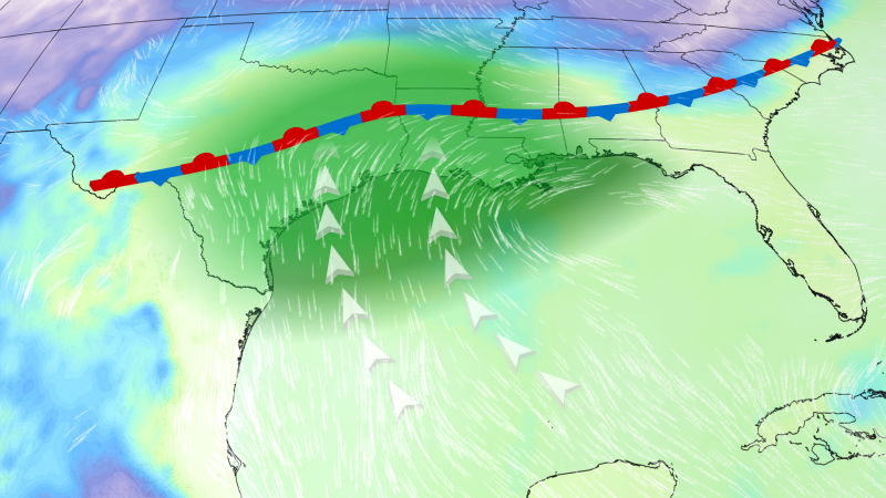
Major flood threat for Texas and Gulf – Significant flooding risks have escalated across Texas and the Gulf Coast, with meteorologists warning of a multi-day deluge that could be amplified by a developing tropical system. This event, projected to span from Monday to Thursday, poses a heightened threat to regions from central Texas to central Mississippi, affecting over 20 million residents. The National Weather Prediction Center has raised the flood risk to its highest level—Level 3 out of 4—across parts of Texas, Louisiana, and Mississippi, a rare occurrence in the U.S. since July 2025. Preliminary forecasts suggest rainfall totals could exceed 5 to 10 inches, with some areas potentially receiving even higher amounts.
Tropical System Fuels Unprecedented Rainfall
The current weather pattern is being driven by a system that may evolve into the first tropical storm of the Atlantic season. This development could draw moisture from the remnants of last week’s Tropical Storm Cristina, which originated in the Eastern Pacific. If the system shifts toward the northwest Gulf by late Tuesday or Wednesday, it might qualify as a tropical depression or storm, earning the designation Arthur if it reaches storm status. Such a transformation would trigger tropical storm watches or warnings for coastal regions as early as Tuesday, intensifying the flood risk.
Rescue Operations Amid Rising Waters
Emergency responders have already begun addressing the impacts of heavy rainfall, with multiple water rescues reported in central and southern Texas. In Bandera County, authorities searched for a driver whose vehicle was swept away by floodwaters on Monday morning, according to Judy Lefevers, the Emergency Management Coordinator. Meanwhile, Andy Brown, the director of emergency management in Travis County, noted that about 80 low water crossings had flooded by Monday, forcing crews to assist stranded drivers. Similar incidents were documented in Williamson County, where two separate rescues occurred at low water crossings, as shared by county spokesperson Connie Odom.
“I have not seen flooding like that in Waco before,” stated Matthew Kiel, a Texas Game Warden. He added that most low water crossings in McLennan County, where Waco is located, had been submerged, along with those in Milam, Williamson, and Burleson counties.
Chris Lopez, the Bexar County Fire Marshal, reported that several vehicles were stranded on Interstate 35 in Waco during Sunday night’s downpours. These incidents highlight the widespread disruption caused by the extreme rainfall, which has already led to localized flooding in central Texas. The National Water Center emphasizes that the combination of the stalled front and the system’s moisture will produce rainfall rates of 3 to 5 inches per hour, potentially causing prolonged flooding in vulnerable areas.
Geographic Zones of Concern
Forecasters have outlined specific regions at risk over the coming days. From Monday night through Tuesday, the most critical flooding concerns are expected to concentrate in South Texas, extending up the coast to Houston, and into western and central Louisiana. West-central Mississippi will also face elevated risks. By Tuesday to Tuesday night, the focus shifts to coastal Texas, southwest Louisiana, and a small portion of central Mississippi, with localized flooding possible in central and southern Alabama as well as west-central Georgia.
Wednesday is anticipated to see the heaviest rainfall, with the potential for widespread impacts. The National Water Center’s Key Messages for the Flash Flooding threat indicate that the situation could worsen as the system lingers, exacerbating the challenges for residents and infrastructure. The timing of the storm’s development will determine the extent of its influence, but even if it remains over land, its moisture will continue to drive intense precipitation rates.
Historical Context and Forecast Outlook
The current Level 3 threat has not been issued for such consecutive days in the U.S. since July 2025, underscoring the severity of the situation. While the system’s path is still uncertain, its potential to become a tropical storm could elevate the risk further. If Arthur forms, coastal areas may face not only flash flooding but also gusty winds and coastal erosion. Even without tropical storm status, the heavy rain alone is expected to overwhelm drainage systems and lead to urban flooding in low-lying areas.
Authorities urge residents to stay alert, particularly in regions prone to flooding. The Texas Department of Transportation reported that vehicles were stranded on highways due to the intense downpours, emphasizing the need for proactive measures. With the possibility of additional rainfall, the threat of widespread impacts could persist through midweek. The National Hurricane Center has highlighted that the system’s development is still medium-probability, but its role in amplifying rainfall is already clear.
Community Response and Preparedness
Local emergency management teams are working to coordinate relief efforts as the situation unfolds. In Bandera County, responders are continuing searches for missing individuals, while in Travis County, crews are monitoring flooded crossings. The rapid response from agencies in these areas has mitigated some risks, but the scale of the event suggests that further action will be necessary. Officials are advising residents to avoid low-lying areas, keep emergency kits ready, and monitor updates from the National Weather Service.
As the storm system moves, its interaction with existing weather fronts will determine the exact intensity and duration of rainfall. The National Water Center has stressed that even without a tropical storm, the current setup could lead to life-threatening conditions in certain zones. With over 20 million people under flood watches, the region is bracing for a significant test of its preparedness and infrastructure resilience.
More info: https://t.co/UZ3ekqUUkq #flooding #txwx
pic.twitter.com/CPSGQUS1ut
