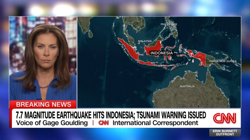
Indonesia issues tsunami warning following 7.7 magnitude earthquake

Daftar Isi
Tsunami Alert Raised After Powerful 7.7 Quake Shakes Indonesia’s Northern Coast
Earthguardiansonline.com – Emergency officials across Indonesia activated a tsunami warning on Saturday morning after a powerful 7.7 magnitude earthquake rippled through the nation’s northern coastline. The seismic event, which struck early in the local day, prompted immediate evacuation orders for coastal communities stretching across multiple islands in the archipelago.
Seismologists at the United States Geological Survey documented three significant aftershocks following the main tremor, registering magnitudes of 5.9, 5.6, and 6.1 respectively. These secondary quakes reinforced concerns about potential coastal flooding and prompted authorities to maintain heightened alert levels across vulnerable regions.
Evacuation Orders and Regional Response
Indonesia’s Meteorology, Climatology and Geophysics Agency directed citizens to avoid beaches and riverbanks until further notice. Officials emphasized that the earthquake originated at a shallow depth beneath the ocean floor near Flores Island, creating conditions favorable for tsunami generation. Residents living along affected coastlines received urgent instructions to relocate to elevated terrain as a precautionary measure.
Meanwhile, Australian emergency management agencies confirmed that no tsunami threat currently exists for their territory. The distinction between regional and international impact zones demonstrates how earthquake-generated waves can affect distant areas differently based on geographic positioning and ocean depth variations.
Human Impact and Infrastructure Concerns
Preliminary assessments from the USGS indicate that casualties and structural damage remain possible, though Indonesian government officials have not yet released comprehensive figures. The agency’s intensity pager system estimates approximately 500,000 individuals experienced very strong or severe ground shaking during the event.
Such intensity levels can produce slight to moderate damage in well-constructed buildings while potentially causing severe destruction in structures built with less rigorous standards. This disparity highlights ongoing challenges in ensuring uniform building codes across Indonesia’s diverse urban and rural landscapes.
A Nation Positioned on the Ring of Fire
Indonesia’s vulnerability to seismic activity stems from its location along the Ring of Fire, a vast geological belt encircling the Pacific Ocean. This tectonic boundary generates frequent earthquakes and volcanic eruptions, making the region one of the most seismically active zones globally. The geological formation extends from Japan and Indonesia on the western Pacific rim to California and South America on the eastern side.
Historical records reveal Indonesia has endured numerous catastrophic earthquakes throughout its modern history. The most devastating occurred in 2004 when a magnitude 9.1 earthquake struck Sumatra island, triggering massive tsunami waves that claimed more than 220,000 lives along the Indian Ocean coastline. Indonesian citizens accounted for over half of those tragic fatalities.
Recent decades have brought additional severe events. In August 2018, a 6.9 magnitude earthquake devastated Lombok island, killing hundreds of residents. Later that same month, a series of powerful tremors shook multiple islands across the South Pacific and Indonesian territories. September 2018 brought another major disaster when a 7.5 magnitude earthquake combined with tsunami waves to strike Sulawesi island, resulting in hundreds additional deaths.
The most recent significant event occurred in November 2022, when a 6.5 magnitude earthquake hit the Cianjur region in West Java province, claiming hundreds of lives and causing widespread infrastructure damage throughout the area.
Ongoing Monitoring and Future Outlook
Emergency response teams continue monitoring the situation closely as aftershocks may continue for days or even weeks following the main event. Coastal communities remain on alert while officials assess structural integrity of buildings, bridges, and critical infrastructure throughout the affected zones.
International aid organizations have prepared contingency plans to deploy resources if needed, though Indonesian authorities have not yet requested external assistance. The situation remains fluid as meteorological agencies track potential tsunami wave propagation and seismologists monitor additional seismic activity in the region.
Residents in vulnerable areas are advised to maintain emergency supplies, stay informed through official channels, and follow evacuation directives without delay. The coming hours and days will determine the full scope of damage and the speed of recovery efforts across Indonesia’s earthquake-prone northern coastline.
Related Reading
Frequently Asked Questions
What is Indonesia issues tsunami warning following 7 7?
Indonesia issues tsunami warning following 7 7 is the main topic of this guide. The article explains the context, practical details, and next steps readers should understand.
Why does Indonesia issues tsunami warning following 7 7 matter?
Indonesia issues tsunami warning following 7 7 matters because readers are looking for a useful answer, not just a short summary. Good content should match search intent and help them decide what to do next.