1 dead as dangerous storms intensify in the central US
1 Dead as Intense Storm System Unleashes Destruction Across Midwest
1 dead as dangerous storms intensify – Severe weather has intensified across the central United States, with another wave of powerful thunderstorms set to strike regions already battered by previous outbreaks. The latest round of storms brings the potential for destructive winds, tornadoes, and hail, posing a renewed threat to communities. A 54-year-old man was killed in Des Moines, Iowa, after being hit by a falling tree during Thursday’s first storm phase, according to a city police statement. The incident occurred in a homeless shelter as the storm system moved through the area, with the tree disintegrating and crashing into the structure. Authorities are still working to identify the victim, though the event marks the first fatality of the current weather event.
Tornado Watches Expand to Major Urban Centers
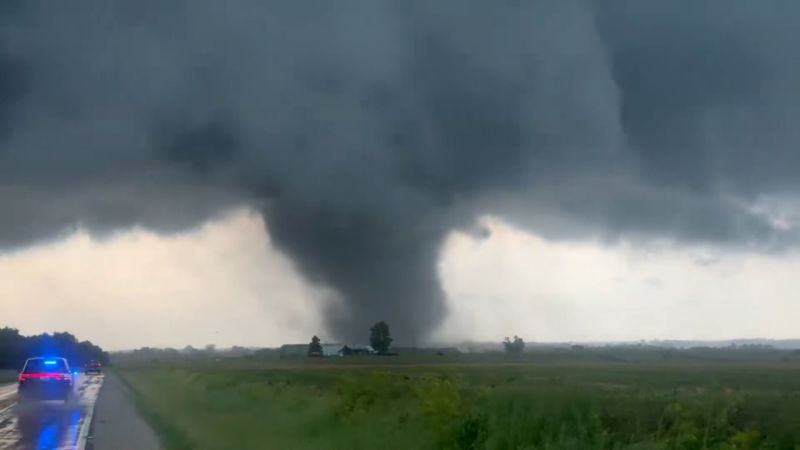
Forecasters have issued tornado watches covering parts of Illinois, Indiana, Michigan, and Ohio, extending the warning period until 2 a.m. EDT. The second phase of storms, which began midday, has already generated tornadoes in the Midwest, with a tornado emergency declared for Marshall County, Illinois, at 5:11 p.m. CT. Emergency responders are evaluating damage in Streator, Illinois, a city located about 30 miles east of the affected area, following reports of a suspected tornado that struck in the late afternoon. Video footage shows extensive destruction, including a residential home completely flattened and at least one resident rescued from the wreckage.
“At this time, there are no reported fatalities, and we are incredibly grateful for the safety of our residents and the quick action of emergency personnel, both in Streator and regionally,” said Streator Mayor Tara Bedei in a statement. The mayor emphasized the urgency of the situation, noting that the city’s infrastructure and emergency services are under heightened strain.
The storm system is expected to affect over 20 million people in Iowa, Missouri, Illinois, Indiana, Wisconsin, Michigan, and Ohio, with cities like Chicago, South Bend, and Fort Wayne, Indiana, as well as Grand Rapids and Kalamazoo, Michigan, included in the high-risk zones. Destructive winds, intense tornadoes, and heavy rainfall are once again a possibility, with gusts exceeding 75 mph threatening to uproot trees and power lines. In some areas, wind speeds could surpass 80 mph, creating a dangerous environment for outdoor activities and travel.
Wednesday had already set a record for severe storm activity, with a powerful line of thunderstorms sweeping across Wisconsin, Illinois, and Michigan. These storms knocked out power to over 400,000 homes and businesses, according to PowerOutage.us, and caused widespread damage to roads, vehicles, and buildings. At Chicago-area airports, more than 1,000 flights were delayed or canceled, with NBC 5 Chicago reporting that a roof was partially torn off an apartment complex, prompting evacuations for residents.
As the storm system continues its progression, meteorologists warn that the Midwest is primed for extreme weather. The Weather Prediction Center has raised the flash flood risk to Level 2 out of 4 for parts of Illinois, Wisconsin, Indiana, Iowa, Missouri, and Minnesota, with rainfall rates potentially reaching 2 inches per hour. This deluge, combined with already saturated ground from earlier storms, increases the likelihood of urban flooding and challenges for drainage systems. Areas with poor drainage, such as low-lying neighborhoods and industrial zones, are particularly vulnerable to water accumulation.
Supercells and Severe Weather Patterns
Some of the storms in Thursday’s second wave have evolved into supercells, which are capable of producing long-lasting, high-intensity tornadoes. These weather systems are expected to target far eastern Iowa, northern Illinois, and southern Wisconsin, where tornadoes could reach EF3 strength or higher. Hailstones larger than limes are also anticipated, adding to the risk for vehicles, crops, and outdoor equipment. The National Weather Service has issued multiple alerts, urging residents to remain vigilant and take shelter as needed.
Although the primary storm activity is projected to subside by late Thursday night, isolated thunderstorms may persist into Friday morning, moving toward the Appalachian region. This ongoing pattern highlights the persistent threat of severe weather, with over 1,000 reports of hail, wind damage, and tornadoes documented since Sunday. The cumulative impact of these storms has led to widespread disruptions, from power outages to transportation delays, and has tested the resilience of emergency services across the Midwest.
Residents in affected areas are advised to monitor updates from local authorities and prepare for potential hazards. The city of Des Moines, where the fatality occurred, is conducting a thorough investigation into the circumstances of the incident, while Streator and other cities are assessing the extent of damage. The National Weather Service has also warned that the high-speed winds and heavy rain could lead to secondary issues, such as downed power lines and debris hazards, requiring additional precautions from the public.
As the storm system moves, its effects will continue to be felt across multiple states. The combination of strong winds, torrential rain, and tornado threats underscores the complexity of the current weather event. With over 1,000 flights canceled and thousands of homes affected, the situation serves as a reminder of the power of severe weather and its ability to disrupt daily life on a large scale. Authorities are working closely to provide timely updates and ensure that communities are equipped to handle the ongoing challenges.
Thursday’s storms represent the final surge of an active weather pattern that has already left a significant mark on the central U.S. The prolonged activity has contributed to flash flood risks, with urban areas facing the highest threat due to their dense infrastructure and limited natural drainage. As the region braces for more severe conditions, the focus remains on mitigating damage and protecting lives. The National Weather Service continues to track the system, providing critical information to help residents stay safe during the next phase of the storm cycle.
