Two storms in two weeks: El Niño has taken down Hawaii’s hurricane force field

Daftar Isi
Hawaii Faces Back-to-Back Tropical Threats as El Niño Strips Away Its Natural Storm Shield
Earthguardiansonline.com – For the second consecutive week, the Hawaiian Islands find themselves squarely in the path of a strengthening tropical system. As of 5 a.m. ET, Tropical Storm Moke sat roughly 545 miles southeast of Hilo on the Big Island, packing maximum sustained winds of 45 mph while tracking west-northwest at a steady 8 miles per hour. Forecasters expect the system to hold its tropical-storm classification through its closest approach, with the eye passing well south of the island chain. Even so, the outer bands should deliver sustained heavy rainfall and sharp wind gusts to communities still patching up damage from last week’s devastation.
The Aftermath Still Fresh
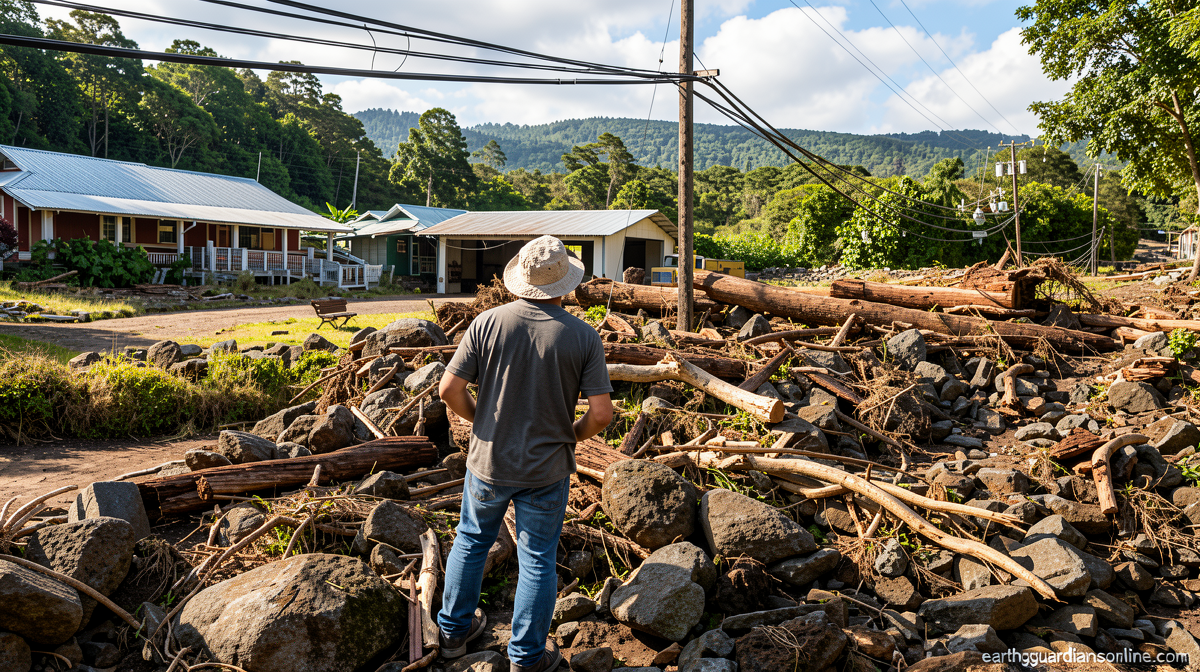
Just seven days earlier, Hurricane Lala spun dangerously close to the southern coast of the Big Island. Its torrential outflow unleashed more than three feet of rain in localized pockets along the windward slopes, triggering cascading landslides and flash floods that severed road access to small towns, leveled residential structures, and knocked out segments of critical utility infrastructure. At least one death has been attributed to that storm’s effects. The scale of destruction in such a short span underscores how rapidly the islands’ usual climate insulation has collapsed.
Why the “Force Field” Has Failed
In most calendar years, Hawaii enjoys an almost uncanny exemption from direct tropical-storm and hurricane impacts. The mechanism is straightforward: cooler sea-surface temperatures and strong upper-level shear winds in the surrounding Pacific act as a natural barrier, sapping energy from any cyclone that drifts west or northwest toward the archipelago. Tropical cyclones draw their fuel from warm ocean water and flourish when the surrounding upper-level wind field is relatively calm. Cooler waters and hostile shear deprive them of both advantages simultaneously.
The developing Super El Niño episode is dismantling that protection on two fronts. First, it is elevating sea-surface temperatures across the eastern and southeastern Pacific — precisely the corridor where Pacific basin storms form and subsequently steer toward the islands. Second, it is warming waters directly south of Hawaii, removing the final thermal barrier that would otherwise weaken a system before it reaches the coast. With both safeguards degraded, storms that might have dissipated harmlessly in a neutral year now retain enough intensity to inflict serious damage even without making landfall.
A Landfall Streak That Survived — Barely
Hurricane Lala came close enough to threaten a direct hit on the Big Island, yet its center skirted just offshore of the southern tip. That narrow margin preserved a remarkable statistical record: Hawaii has logged zero hurricane landfalls since Category 4 Hurricane Iniki struck Kauai from the southwest in 1992. More than three decades without a direct hurricane strike ended not with a landfall, but with a near-miss that nonetheless produced catastrophic rainfall effects.
The episode also illustrates a critical point for residents and planners: a storm need not touch down to generate life-threatening hazards. Wind-driven rain bands, storm surge along exposed shorelines, and gravity-driven slope failures can all occur well before the eye crosses the coastline.
Statistical Improbability and the Role of Steering Currents
Matthew Rosencrans, the lead hurricane-season forecaster at the National Weather Service, noted that even during vigorous El Niño seasons, it remains uncommon for a tropical cyclone to close within 300 nautical miles of the Hawaiian Islands. The climatological norm, he explained, is roughly one such close approach per season.
“Very bizarre,” Rosencrans described the two-week window in which two separate systems have tracked toward the islands. He attributed the anomaly to a temporary alignment of atmospheric steering currents that channeled both storms in Hawaii’s direction.
With Moke completing the pair, the state has already experienced twice its typical annual frequency of close tropical-cyclone approaches. Rosencrans added that a third such event remains probable before the season concludes, though he cautioned that the steering patterns responsible for this unusual clustering could shift on short timescales, potentially granting the islands a reprieve.
The Atlantic Contrast
The same El Niño dynamics that amplify Pacific activity suppress Atlantic hurricane formation. Enhanced upper-level shear associated with El Niño tends to tear apart nascent Atlantic disturbances before they can organize into storms. That inhibiting signature has been plainly visible this season, with the Atlantic basin remaining unusually quiet for extended stretches. The contrast between a hyperactive eastern Pacific and a subdued Atlantic underscores how El Niño redistributes tropical-cyclone risk across ocean basins rather than simply increasing global storm counts.
What Comes Next
For Hawaii’s residents, the immediate concern is Moke’s outer rain bands and the compounding vulnerability of infrastructure already stressed by Lala. For forecasters, the question is whether the steering-current alignment that produced this unprecedented two-week sequence will persist or relax. El Niño raises the probability of linked outcomes — more storms forming in the eastern Pacific, warmer waters fueling their approach — without guaranteeing that every system will intensify to hurricane strength. The islands’ historical record of near-misses and the current statistical anomaly together suggest that preparedness, not complacency, remains the appropriate posture through the remainder of the season.
Related Reading
Frequently Asked Questions
What is Two storms in two weeks?
Two storms in two weeks is the main topic of this guide. The article explains the context, practical details, and next steps readers should understand.
Why does Two storms in two weeks matter?
Two storms in two weeks matters because readers are looking for a useful answer, not just a short summary. Good content should match search intent and help them decide what to do next.