Tropical storm warning issued in Louisiana for major flood threat
Tropical Storm Warning Issued in Louisiana Amid Major Flood Threat
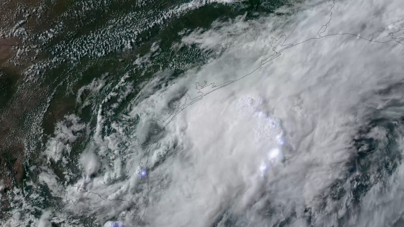
Tropical storm warning issued in Louisiana – A tropical storm warning has been issued for parts of Louisiana’s coastline as a developing system approaches, which may soon transition into a brief tropical storm. The National Hurricane Center has labeled the system Potential Tropical Cyclone One, indicating it could bring tropical storm conditions to land within 72 hours, potentially as early as Wednesday morning. This system is expected to evolve into Tropical Storm Arthur once it moves into the northwest Gulf of Mexico by early Wednesday, before heading inland over extreme east Texas or southwest Louisiana by late Wednesday or early Thursday.
Heavy Rainfall Looms as Primary Hazard
While the warning focuses on potential tropical storm winds, the more pressing threat lies in the system’s intense rainfall. Forecasters predict widespread flooding across South Texas, Louisiana, Mississippi, and Alabama, with rainfall rates of 3 to 4 inches per hour possible in some areas. Additional 4 to 8 inches of rain could fall through Thursday, particularly in southern Louisiana, central and southern Mississippi, and the western Florida Panhandle. In some regions, totals could reach up to a foot, straining infrastructure and prompting emergency responses.
“This just dumped a tremendous amount of rain,” said Picayune Fire Department Chief Joshua Abercrombie, highlighting the suddenness and severity of the downpours.
Already, the system has caused significant damage, with over 120 flood reports logged since Sunday afternoon. The National Weather Service noted that Texas, Louisiana, and southern Mississippi have been inundated by flooding from the system’s moisture colliding with a stalled front, creating conditions ripe for catastrophic impacts. Flood watches have been issued for more than 27 million people across these regions, emphasizing the scale of the threat.
Impact on Communities and Emergency Response
Emergency officials are working tirelessly to mitigate the crisis. In Bandera County, northwest of San Antonio, a woman was tragically swept away by floodwaters early Monday morning, her vehicle found several miles downstream and completely submerged. She had called 911, describing her situation as “floating downstream at a high rate of speed and unable to exit her vehicle,” according to the sheriff’s office. Swift water rescue teams were deployed after losing contact with her, underscoring the danger posed by the deluge.
Meanwhile, in the greater Houston metro area, Montgomery County reported several stranded vehicles due to street flooding on Tuesday. Sheriff spokesperson Miranda Hahs noted that at least 10 street closures occurred, disrupting traffic and requiring immediate intervention. Similar scenarios were observed in Travis, Bexar, and Williamson counties, where over 80 low water crossings were flooded on Monday, according to county Judge Andy Brown.
In Picayune, Mississippi, floodwaters reached waist-deep levels on roads and submerged homes, prompting rescue efforts. Fire crews saved a family, including an infant, from a house with knee-deep water. While no injuries were reported in the city, the rapid accumulation of rain left residents unprepared for the sudden flood conditions. “We’re not used to flooding in the areas we got it in,” Abercrombie remarked, reflecting the community’s struggle to adapt.
Shreveport, Louisiana, also faced challenges as floodwater entered commercial buildings and a technical college on Monday. Caddo Parish Sheriff’s Deputy John Lane reported 52 water rescue calls within a six-hour window, though it remains unclear how many required actual intervention. These incidents illustrate the far-reaching effects of the storm, from isolated tragedies to widespread disruptions.
State Actions to Address the Crisis
Texas Governor Greg Abbott has taken decisive action, declaring a state of disaster for 101 counties and activating additional emergency response resources. This move underscores the gravity of the situation, as floodwaters continue to threaten lives and property. The governor’s declaration aligns with ongoing efforts to coordinate relief and ensure public safety across affected regions.
As the system moves, its trajectory remains a key concern. The National Hurricane Center’s forecast suggests that Tropical Storm Arthur will bring sustained winds of 40 mph or greater to the warning area, spanning from Sabine Pass to Morgan City, Louisiana. However, the primary focus remains on the deluge, which has already triggered hazardous conditions in multiple states.
Preparedness and Future Outlook
Residents in the Gulf states are urged to remain vigilant, as the system’s influence is expected to last through the week. The Weather Prediction Center has issued a Level 3 out of 4 threat for flash flooding in parts of Texas, Louisiana, Mississippi, and Alabama from Tuesday to Thursday. This rating reflects the high probability of life-threatening inundation, with some areas anticipating rain totals exceeding 9 inches by Tuesday morning.
Authorities are closely monitoring the situation, with updates available through CNN Weather. The combination of heavy rainfall and the region’s vulnerability to flooding has created a critical scenario, requiring coordinated efforts between local and state agencies. While the storm may be short-lived, its impact could linger for days, necessitating ongoing preparedness and response strategies.
As the system progresses, its ability to generate flash floods in previously dry areas raises concerns. The unexpected nature of the rainfall highlights the need for real-time monitoring and swift action to protect communities. With over 27 million people under flood watches, the stakes are high, and the coming days will test the resilience of those in the path of the storm.
The National Weather Service continues to track the system, providing alerts and updates as conditions evolve. While the exact path and intensity may shift, the potential for widespread flooding remains a central focus. Residents are advised to stay informed, prepare for possible evacuations, and take shelter if necessary as the storm’s effects intensify across the region.
