Severe thunderstorm outbreak to target the Midwest Wednesday with intense tornadoes possible
Severe Weather Event Targets Midwest Wednesday, Tornado Threats Rise
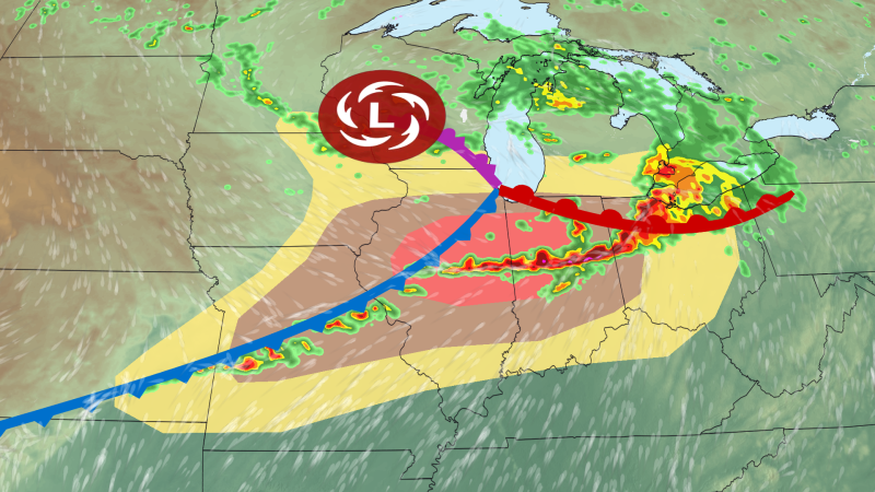
Severe thunderstorm outbreak to target the Midwest – A powerful storm system, more intense than typical for June, is expected to trigger a severe thunderstorm outbreak across the Midwest on Wednesday, with the potential for long-lasting tornadoes, large hail, and widespread damaging wind gusts. This weather event marks a significant escalation in the region’s storm activity, adding to the challenges faced by an area already struggling with relentless weather conditions this month. The unfolding forecast suggests a multi-day storm surge, with the most critical threat emerging in the afternoon as the weather system intensifies.
The recent series of storms last week has already left its mark, generating over 1,500 reports of tornadoes, wind, and hail in the central United States. While the immediate aftermath of those storms has waned, the atmosphere is primed for a fresh round of severe weather. This new wave of activity is anticipated to begin Wednesday morning, with powerful storms rolling through Iowa and northern Illinois. These early storms have already produced a notable hurricane-force gust of 94 mph near Albion, Iowa, approximately 50 miles northeast of Des Moines, Iowa, according to the National Weather Service.
These storms produced a hurricane-force wind gust of 94 mph near Albion, Iowa — about 50 miles northeast of Des Moines, Iowa.
By early Wednesday afternoon, the initial storms have lost much of their intensity, primarily posing a flood risk in Illinois and Indiana. However, the threat is far from over. A secondary wave of storms is expected to follow, driven by the same atmospheric conditions that have already set the stage for severe weather. The most concerning activity will center around an area stretching from Missouri to Indiana, with the risk of tornadoes peaking in the early evening.
The National Weather Service has issued a Level 4 out of 5 risk for severe thunderstorms in parts of Illinois and Indiana, including the city of Indianapolis. The rest of the region faces a Level 3 risk, indicating a substantial probability of damaging winds and hail. Supercell thunderstorms, which are known for their ability to spawn tornadoes, are forecast to move through these zones. While supercells are the primary source of tornadoes, the potential for twisters exists in other storm systems across the Midwest and into the Plains as well.
Weather experts warn that the tornadoes forming in the high-risk areas could reach EF3 strength or higher, capable of causing extensive damage. These severe tornadoes may also travel longer distances than average, increasing the likelihood of widespread impact. Although EF3-level twisters are not guaranteed, the conditions are favorable for their development, making this a more significant threat than usual for the season. The strength of the overall storm system, which is unusually robust for June, contributes to the extreme moisture and energy levels fueling the storm activity.
As the day progresses, the severe thunderstorm threat will expand slightly in the evening. A cold front moving through the region is anticipated to trigger additional storms, extending the reach of the weather system into parts of Missouri and eastern Kansas. This front will also play a role in shifting the primary danger from tornadoes to damaging wind gusts, which could surpass 75 mph later in the night. The wind threat will intensify as the storms merge into organized lines, starting from eastern Kansas and gradually moving into western Ohio.
Staying active through the night, the storm system will generally track southeastward, maintaining its intensity until the early hours of Thursday. By then, the majority of the threats will clear out of the Midwest, transitioning to the East as the weather pattern shifts. This transition is expected to bring a new set of challenges to eastern regions, though the exact nature of the storm system’s movement remains under close observation.
Understanding the Storm System’s Unusual Strength
The root of this severe weather event lies in an atypical June storm system, which has created an environment ripe for explosive storm development. Typically, June is a time of more stable atmospheric conditions, but this system has disrupted the usual pattern. The combination of warm, moist air from the Gulf of Mexico and cold, dry air from the north has generated an unstable environment, leading to the formation of powerful thunderstorms. This clash of air masses is contributing to the unusually high energy levels, which are driving the intensity of the current outbreak.
Weather models indicate that the storm system will continue to provide a consistent supply of moisture and energy throughout Wednesday. This will keep the threat of tornadoes and damaging winds elevated, even as the initial storms wane. The persistence of these conditions is a key factor in the extended risk period, with meteorologists emphasizing that the storm system’s strength is the primary reason for the heightened threat compared to other times of the year.
Additionally, the timing of the storm’s arrival aligns with a period of increased atmospheric instability. The afternoon hours are expected to see the most severe activity, as the sun’s heating of the surface further fuels the development of thunderstorms. This creates a feedback loop where the storms grow stronger, leading to more intense downpours, gusty winds, and the potential for tornado formation. The region’s weather-weary population may find this latest development particularly challenging, as it follows a week of relentless storms and leaves little time for recovery.
Impacts and Preparedness
Residents in the Midwest are being urged to prepare for the worst-case scenario. The combination of EF3-level tornadoes and damaging winds means that multiple hazards could be present simultaneously. This is especially concerning for areas like Indianapolis and parts of Illinois and Indiana, which are under the highest risk. Local authorities are monitoring the situation closely, with emergency plans in place to address potential damage and ensure public safety.
While the immediate focus is on Wednesday’s storms, the broader implications of this weather pattern are worth noting. The persistence of the storm system suggests that the Midwest may experience a prolonged period of severe weather, potentially affecting agricultural and infrastructure sectors. Farmers are particularly vulnerable, as the extended storm activity could damage crops and delay planting seasons. Meanwhile, the energy from these storms could lead to power outages and structural damage in urban areas.
Meteorologist Briana Waxman highlighted the significance of the current storm system, noting that its strength is a rare occurrence for this time of year. “The amount of moisture and energy in the atmosphere is creating a perfect setup for severe weather, which is why we’re seeing these intense storms,” Waxman explained. The timing of the event also coincides with a transition period in the climate cycle, which may contribute to the frequency and intensity of such outbreaks in the coming months.
As the storm system moves, the Midwest will eventually be relieved of its severe weather burden, but the lessons from this event will remain. The region’s ability to handle such weather events is being tested, and the upcoming days will serve as a critical assessment of preparedness and resilience. With the threat of tornadoes and damaging winds on the horizon, vigilance and timely responses will be essential to mitigate the impact of this summer’s first major storm surge.
